
The Desert Training Center
“The Place that God Forgot”
In the last several decades our country and others have been at war in the deserts of the Middle East and beyond. The first of those wars, Desert Shield and Desert Storm were unlike the wars in Korea and Vietnam and those we’ve fought since. America united behind the men and women who went overseas to fight and supported them all the way to victory. It reminded many older Americans of a time more than fifty years ago when they were just beginning to prepare for war – the largest war in history.
The Second World War covered the globe and called for all Americans to make every effort in the drive to victory. In the early days of the war the United States Army faced the daunting task of preparing raw recruits for a war then being fought in the North African desert against Erwin Rommel’s Africa Korps.
An obscure yet vital part of that effort was known as the Desert Training Center. The general public knows almost nothing about the part it played in the war effort. Even fewer people are aware that today there are still remains of the camps and maneuver areas used by the troops who trained for war.
Like Operation Desert Storm the war in North Africa was a new war fought in new terrain. The United States was about to enter the age of the Blitzkrieg and the tank. The man picked to prepare us for this fight was an iconoclastic and aging General named George S. Patton Jr. The rest, as they say, is history.
In the half century since the Desert Training Center (later called the California-Arizona Maneuver Area) closed much has changed. Now missiles, computers and laser beams perform feats that would have been considered impossible by General Patton and his troops. Yet much remains, including the scattered and largely forgotten ruins of places that prepared a generation of young Americans to change their world, and ours. Some of these places are almost in our own back yards.
A Brief History:
The Desert Training Center (DTC) became operational on April 30th 1942 under the command of General George S. Patton Jr. Patton himself had selected the site of the DTC after surveying the area from the air, and on foot and horseback. Patton established the first base camp of the DTC about 25 miles east of Indio at Shavers Summit (now known as Chiriaco Summit, after the family which owns the land, and home to the General Patton Memorial Museum).
Patton only served in the Desert Training Center for a little less than four months, being called away to eventual service in Operation Torch in late July 1942. Yet it was his vision that created it, often at his own expense, and his energy that sustained it throughout its brief history.
The troops said the DTC was, “the place that God forgot.” The immediate purpose of the Training Center was to prepare troops for desert campaign against German and Italian forces in North Africa.
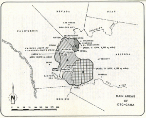
At it’s height the DTC consisted of twelve divisional camps, numerous support camps, and stretched from Indio in the west to Prescott in the east, from Yuma in the south to Searchlight, Nevada, in the north. In it’s final form it covered approximately 18,000 square miles and was divided into three areas. Area A covered parts of California and Nevada, area B part of southwest Arizona and C part of northwestern Arizona.
When Patton left the Center, General Walton H. Walker (who would later served under Patton in Northwest Europe) assumed command on August 2nd, 1942. He was later relieved by General Alvan Gillem Jr.
After the close of the North African Campaign the name of the DTC was changed to the California-Arizona Maneuver Area (CAMA) to better reflect it’s training of troops for all theaters of the war. At it’s height the CAMA reached a strength of 190,000 men under the command of General Charles H. White.
CAMA officially closed at midnight on April 30th, 1944. The 10th Corps being the last unit to hold maneuvers in the CAMA. With it’s closure came an immense effort to close the camps, ship out thousands pieces of equipment and tons of material. The last facilities to close were the Pomona Ordnance Base, the Base General Hospital Depot and the HQ at Camp Young.
In it’s two year history the DTC-CAMA trained approximately one million men in the largest military maneuver area the world has ever seen. Units trained there include the 3rd, 4th, 5th, 6th, 9th, and 11th Armored Divisions and the 5th, 7th, 8th, 33rd, 77th, 79th, 81st, 89th, 90th, 93rd, 95th, and 104th Infantry Divisions.
Judging from the performance of the troops in combat General Patton had been correct when he said, “If you can work successfully here, in this country, it will be no difficulty at all to kill the assorted sons of bitches you will meet in any other country.”
The Training Camps
The heart of the DTC-CAMA were the 12 Divisional training camps. Most of these camps were laid out following the same basic plan. Notable exceptions to this layout are Camps Young, Pilot Knob and Bouse.
The camps were laid out in a rectangular shape, with the Divisional Headquarters located roughly in the middle of the camp. Most of the camps were two or three miles long and about one and a half miles wide. (If you look carefully at the map of Rice above, you can see the outline of Camp Rice to the right of Rice just off the road.)
Within this rectangle streets were arranged in a rough grid pattern. Some street names are common to most of the camps; those being, Range, North (south, etc.) Boundary, Headquarters, Kitchen, Latrine, and Motor Pool Roads.
The main entrance to the camp led to a Flag Circle, around which was situated the Divisional Headquarters. The road around the circle was usually marked with large rocks, and must have looked impressive when the camps were in use.
That’s the basic layout of the camps. For a closer look, lets take a trip to what’s been called “The Crown Jewel” of the DTC-CAMA, Camp Iron Mountain.
Visit To A “Crown Jewel”
Today the best preserved of all the training camps is Iron Mountain (for a brief description of all the camps see the appendix). Most of the camp was fenced in 1973 to help protect it from off road vehicles. Perhaps the best way to describe it is for you to hop into my Jeep and come on along for a tour of what has been called “The Crown Jewel” of the training camps, Camp Iron Mountain.
Driving west from Parker Arizona on California State Route 62 you’ll pass Camp Rice, the town of Rice (which is for sale by the way!) and the Freda Railroad siding, site of the Freda Quartermaster Depot, where tanks, men and equipment were delivered for service at Iron Mountain. About two and a half miles past the turn off to the Iron Mountain Pump Plant (part of the Metropolitan Water District) we come to the turn off to the camp.
Iron Mountain is marked, as all the California camps are, with a large cement obelisk. Attached to it is a plaque explaining a little about the camp. The road leading back to the camp says “4 WD only.” They aren’t kidding – there’s some pretty rough and sandy territory ahead.
About a mile and a half down this fairly rough road you’ll notice some rockworks off to the right. Following a road to the right you’ll find some rock works outlining buildings or tents and walkways. A bit further down the road are some old artillery canister holders and other remains of the camp.
Once you return to the main road into the camp it’s only about one tenth of a mile until you reach the fence that surrounds most of Camp Iron Mountain. Turning left you’ll pass a turnstile after a short distance. You’ll find these turnstiles situated at different points around the perimeter of the camp. They usually appear at points of interest, though sometimes I haven’t found anything near them inside the fence.
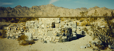
The fence ends in about a mile, but you’ll notice that the camp doesn’t. They neglected to fence the west end of the camp, where you’ll find rock works and other remains. Turning right we now come to the first, and possibly most outstanding artifact in Iron Mountain – “The Catholic Chapel.”
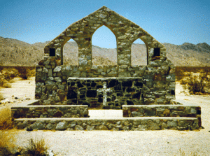
This chapel (or altar) is extremely well preserved, and was built shortly after the camp was founded. I’ve seen a picture of General Patton standing in front of it, which means it had to have been built in the first several months after the DTC became operational. Originally there was a wooden cross at the peak of the arch, but it was later removed.
There are several turnstiles in the chapel area so access to it is easy. Every time I’ve visited it I’ve thought of the many men who must have worshipped there and later died in battle. I find it very moving to touch the place where men sought for peace with God before going around the world to fight and die for our freedom.
If you walk quite a ways “down” (back towards the highway) from the chapel you’ll find many excellent rock outlines of walkways, buildings, etc. Once you get back to your vehicle turn right at the end of the fence and travel for about 6 tenths of a mile to a turnstile located in a wash.
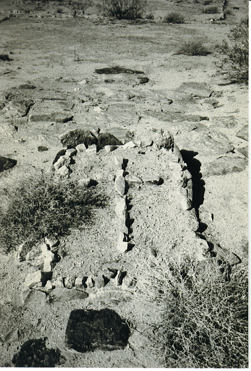
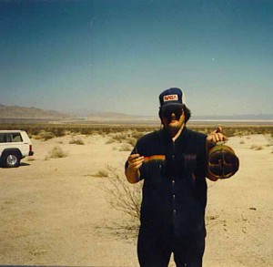
This turnstile leads to the richest area I’ve yet found for rock mosaics. Rock mosaics are pictures, words, and unit ID’s that the troops formed using sand and rock. Many of these still remain today, though their conditions vary, due to erosion, plant growth, and vandalism. Finding these mosaics are the highlight of visiting any of the camps.
To get to the mosaic area you’ll walk straight down the wash for about a quarter to a half mile. Off to the left you’ll see a large rock and to the right lots of old communication wire. Follow the walkway to the right and you’ll discover rockworks and mosaics to the right and left of it.
The first mosaic on the left is remarkable. It’s a large square composed of an ambulance, caduceus, skull & crossbones and another mosaic that’s no longer readable. To the left of the walkway (that is back towards the fence) lie a large rock work “M”, a Star, and a cross (or plus).
From this point in a westerly direction for about a quarter mile you’ll find unit ID’s and mosaics to both the right and the left. Most of the unit ID’s are to the right, with a flag circle just above them. To the left are the mosaics (if you have trouble with directions in the desert remember you should be able to see the Catholic Chapel if you’re facing westward). Several of the rockworks still have some paint (orange or red) on them.
You’ll find rocks spelling out, “HQ BTRY,” SER 905,” “A 905” (as well as B and C), a large American Flag, a star, and more! By the way, if you plan on taking pictures of all this remember that late morning or early afternoon would be the best time. Early morning light will either shine into your lens or throw your shadow across what you are trying to shoot.
Back to the vehicle again and on to the next turnstile. This one leads to what must have been “Officer Country.” I hazard this guess because of the many walkways that have been “paved” with large flat rocks. Pity the poor GI’s who had to carry and lay these things! Straight in from the entrance you’ll find a cross inside a rectangle where several paved rockways converge. Possibly near where the Divisional Chaplain lived?
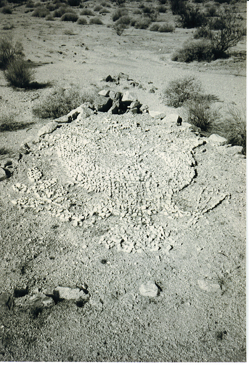
East again from there for a bit and you’ll come to Iron Mountain’s Contour Map. The Contour Map represented the entire area of the DTC-CAMA and was used for maneuvers (or wargames). It’s just inside the perimeter fence with another fence of it’s own. The map has decayed to the point where it’s hard, if not impossible, to recognize any features in it. But it’s fun to try. One thing not to try is getting under the fence. It’s possible, but not a good idea, you’ll only speed up the destruction of this priceless historical artifact.
As you walk around the map you’ll notice a large traffic circle south of it. This is the Flag Circle that marks where the Head Quarters was located. If you walk into the middle of the circle you’ll find the place where the flag once flew. (At this point you are in line with the dirt road that leads into the camp from the highway.)
This time go east again to the third turnstile to find Iron Mountain’s second chapel. You may notice it off the right as you’re driving. It’s about a quarter of a mile in from the fence. This chapel isn’t in nearly as good condition the first one is. It has three cement plaques, which contain some unit ID’s, probably of the units who built it. The numbers are hard to read, but they were Field Artillery Battalions.
Nearby the chapel are some revetments they must have used. While directly in front of it are some very interesting and artistic walkways.
To find a mosaic of the Army Officers symbol (the eagle, clutching arrows in one talon and branches in the other) go down the road you took to the chapel and turn left on the second road you come too. Keep walking straight until you come to a small pile of rocks in the road. Then hang a hard right and you should find it. Be warned, it’s beautiful to look at but hard to photograph!
Well, there are other things to find at Iron Mountain but those are the highlights. I’ve seen other mosaics, but doubt I could find them again! It’s easy to get lost wandering around out there, so if you do find something take those pictures the first time – you might not get a second one.
Two Suggested Trips
After reading all this you might be thinking, “This is great, but where do I start?” Good question!
I’ve outlined below two different trips, one for those of you with access to Four Wheel Drive vehicles and one if you don’t. But regardless of what you drive, both of these trips are well worth your time.
The Museum and Camp Young:
For those of you with two wheel drive vehicles, or if you’d like to start off at the center of the DTC-CAMA, this is the way to do it.
Take I-10 till you reach the Chiriaco Summit exit (about half way between Blythe and Indio California). There you’ll find the General Patton Memorial Museum. It’s full of interesting exhibits and pictures. It’s also the best place to find information on the DTC-CAMA. If you’re really interested in exploring the camps ask for a copy of the “Interpretive Plan.” It’s costs about $8 but is well worth the price.
After leaving the Museum it’s only a few miles west on I-10 to the Joshua Tree Monument exit. Go north to the dirt road that’s marked and follow it. It’s a bit rough but easily passable to any family car (the first time I visited someone had a Honda Prelude out there). You’ll find the marker and a bulletin board down the road. From there you can walk into the camp and explore as much as you want.
Camp Iron Mountain
From Phoenix the quickest way to Iron Mountain is to take I 10 again, but this time turn off at the Vicksburg Road exit. Take Vicksburg road north till it dead ends into State Highway 72 (you’ll pass SR 60 on the way). Follow the signs into Parker, then go straight through the stop lights (there will soon be two!), cross the Colorado River and turn left at the stop sign. From there it’s about an hour’s drive to Camp Iron Mountain.
A Few Important Reminders
You should be able to use the information above to have a good visit to the camps in the DTC-CAMA. But remember, digging and artifact collecting in the camps is strictly prohibited. However artifact collecting at related facilities, gunnery ranges, etc. is allowed according to the Museum, but not allowed by Federal Law. Please cooperate and help preserve these historic sights for generations to come.
Since these sights are pretty remote, be sure to take lots of drinking water, first aid materials, toiletries, and other supplies with you! A CB radio wouldn’t be a bad idea either.
Appendix A
The Training Camps Today
[After the name of each camp are several letters. 4WD = 4 wheel Drive necessary; 2WD = 2 wheel drive o.k]
Arizona Camps
Camp Bouse: (4WD) located north of the small town of Bouse (where you’ll find a plaque commemorating the Camp) in La Paz county Arizona. It was a “mystery post” where the 9th Tank Group tested defense systems. The “Canal Defense Light,” a tank defense method, was fully evaluated here. The CDL was a British idea first advanced in WW I. Briefly the idea was to have search lights with 13 million candlepower on the turrets of tanks to blind and confuse the enemy. British Matilda and U.S. Grant tank were tested with this configuration. The Ninth Tank Group served in Northwest Europe, but never used the CDL’s in combat.
Camp Bouse was unknown to the residents then living in the area due to rigid security precautions. There are roadways, rockworks and rock mosaics left at Camp Bouse, as well as an unusual amount of cement building foundations and sidewalks, firing range, test area etc.
Camp Hyder: (4WD) about 75 miles east of Yuma near the Gila River and Camp Horn. The 77th Infantry Division trained here in April – September of 1943, followed by the 104th Infantry Division. The 77th were the first foot soldiers in the DTC-CAMA. A farm now occupies the site of Camp Hyder, with only two stone pillars marking the entrance to the camp remaining.
Camp Horn: (4WD) located about 50 miles east of Yuma due north of Dateland, a large portion of this camp has been cleared for farming. From June to November, 1943 the 81st Infantry Division trained here. A large pyramidal memorial honoring seven men who died in training is still standing and is almost the only remains of this camp.
Camp Laguna: located 25 miles north of Yuma. No access allowed and condition unknown since it lies completely within the Yuma Proving Grounds. The 3rd and 9th Armored as well as the 79th Infantry Divisions trained here.
California Camps
Camp Iron Mountain: (4WD) located about 50 miles west of Parker on State Route 62. Known as the “Jewel” of the training camps, most of the camp is fenced for protection. It contains two altars, a contour map, many rock works and excellent rock mosaics, etc. (See main article for more information) The 3rd Armored Division trained here.
Camp Granite: (4WD) located across the highway from Camp Iron Mountain. Granite suffers from severe erosion problems, but there are still rock works intact, especially around the flag circle. The road that leads into the camp from the highway also leads to what appears to have been their firing range. You’ll find spent, rusted slugs lying on the surface around the berm the road dead ends into. There is also a remarkable oven made from part of a vehicle and overlaid with stone and cement found there, as well as several rock mosaics. The truly adventurous should check out what’s behind the camp! The 90th Infantry Division trained here.
Camp Coxcomb: (4WD) located on State Route 177, north of Desert Center. Coxcomb has one altar in excellent shape, also a fenced in contour map. Smaller than the map at Iron Mountain, this one has deteriorated even more. While suffering from erosion there are many interesting stone works intact. On the north side of the camp is a large area of collapsed wooden buildings, you’ll also find mosaics, and one small old ammo bunker you can actually walk down into. A road leads north out of the camp to a maneuver area they used. The 6th and 7th Armored and the 93rd and 94th Infantry Divisions trained here.
Camp Ibis: (4WD – though you could park and walk into it since it lies right next to the highway) located on State Route 95 northwest of Needles, just north of Arrowhead Junction. Most of the camp lies on the east side of the highway, but there are stone works, and a 95 x 140 concrete reservoir west of it. Many excellent rock works here, a few mosaics and also much erosion. The 4th and 11th Armored Divisions trained here.
Camp Clipper: (4WD) located about 42 miles west of Needles, Interstate 40 was built through part of this camp. As of this writing Clipper isn’t marked with the usual concrete obelisk. There are many rock works and rock mosaics left in Clipper. There’s also an unusual amount of artifacts left here, due to it’s remote nature. Clipper also contains a 500,000 gallon concrete reservoir. The 33rd and the 93rd Divisions trained here.
Camp Pilot Knob: (2WD) located 15 miles east of Yuma, just off of Sidewinder road. The 6th and 85th Infantry Divisions trained here. Much of this camp is privately owned, and has been cleared. Other than a the roadways, tank tracks and a few tent outlines almost nothing remains of this camp.
Camp Rice: (2WD) located just east of the town of Rice on State Route 62 (between Parker and Camps Iron Mountain and Granite). Nothing left on the site except for faint outline of tents, buildings, roads. The 5th Armored Division was the first unit that trained at Camp Rice, other Armored Divisions followed, so it’s sometimes referred to as “The Armored Camp.”
Camp Young: (2WD) located 25 miles east of Indio, mostly north of Interstate 10 on the turn off to Joshua Tree National Monument. The Interstate was built over the southernmost part of the camp. By turning right onto a marked dirt road you’ll end up at the camp marker and a bulletin board with historical information. From there you can walk into the camp, where much of the rock works remain. Camp Young was the Headquarters of the DTC-CAMA and the first camp constructed.
Appendix B
Other Points Of Interest In The DTC-CAMA
[4WD = 4 wheel Drive necessary; 2WD = 2 wheel drive o.k.]
Palen Pass Defense Area: (4WD) located about 19 miles east of Camp Coxcomb via a 4 Wheel Drive only road. Used during the war for divisional sized maneuvers by troops in the DTC/CAMA.. Doing well in Palen Pass met they were ready to be shipped out! Since the war it’s seen much mining and off road activity. Along the route into the pass you’ll see hundreds of tank tracks, in the pass area itself there are hundreds more. Once you pass through the major wash you’ll find an impact area with craters and shrapnel scattered everywhere. Some artifacts remain, as well as fox holes (check the hills), gun emplacements (complete with remains of sandbags), concertina wire, etc.
Freda Quartermasters Depot: (2WD) located near the Freda Railroad Siding between Rice and Camps Iron Mountain and Granite. Freda was the site where the tanks, personnel and other equipment these camps used was off loaded. There are some rockworks north of the railroad tracks. To get there you’ll have to hike across the railroad tracks. There are rockworks and some cement foundations left. Many of the rock works have been destroyed and deposited into piles. You’ll find other railroad sidings used for similar purposes scattered throughout the DTC-CAMA area.
Lake Cadiz Complex: (4WD) Located Northwest of Camps Iron Mountain and Granite, Lake Cadiz is accessible along the Lake Cadiz road. It’s dirt and 4 WD is recommended. During my two visits there I found some remains but nothing of “the complex” that I’ve read was located there.
The Airfields: (2WD) There were many airfields built to support the DTC-CAMA, as well as train pilots during W.W.II. Some of those directly related to the DTC-CAMA were: Chiriaco Summit, Desert Center, Rice Army, Datelan Army (incorrectly named by the War Department, should be “Dateland!”), Kingman Army and Blythe Army Airfields.